
This eight-day Annapurna circuit trekking guide by Asian Traveler Chris Taylor. He gives intimate details about the country’s fascinating cultures, flora and fauna as well as information on classic high altitude treks and other adventures.
Outward trek along the Marsyangdi Khola, into the Manang basin, over Thorung pass and down into the Kali Gandaki gorge – the world’s deepest – gives the trekker a roundabout tour of the Annapurna massif. It is also one of the most varied and comfortable. There are many hotels and tea houses en route so you do not have to carry camping equipment.

Quick Links
8 Days Annapurna Circuit Trekking Guide
If you are traveling by bus from Kathmandu to Pokhara, you can bypass Pokhara altogether and start this trek from Dumre. Road improvements mean that it is now possible to take a bus from Dumre to Besi Sahar. If you fly into Pokhara, you will have to take a Kathmandu – bound bus to Dumre.
The trek begins with a long walk through the bazaar of Besi Sahar, before ascending steeply over marble rocks.
Now Manaslu and Peak 29 rear their heads above the far end of the valley as the trail reaches Khudi, at the base of a suspension bridge across the Khudi Khola (Khudi river).
Walkthrough the village, past a school on the lower right, to the path on the right bank. Just after the school, it crosses a stream and then travels through two hamlets, across a suspension bridge to the left bank, to Bhul Bhule,> which has hotels and tea houses.
The path begins to climb but in the dry season, you can follow the riverbed and then up a gradual incline to the Manang village of Ngatti, lined with hotels and tea houses. The trail out of the village crosses a stream to the left bank of Ngatti Khola, a tributary that has its source in the snows of 7,893-m (25,895-ft)-high Himal Chuli and across a long suspension bridge to the right bank.
1st day Annapurna Circuit Trekking guide
The trial soon Leaves the bank and climbs up to the crest of the ridge the divides the Marsyangdi and Ngatti. By the tea house at the summit is a well-shaded rest area.
From the rest area, the path follows the left bank of the Marsyangdi River, climbing gradually all the way, through the village of Ranpata, to the Bahundhara pass set at 1,270 m(41,100-ft) where there is a check post. There’s a village on the hill overlooking the pass. Here you’ll find tea houses, shops, and hotels. You can stay overnight in one of the hotels or camp somewhere in the fields around the Bahundhara pass.
2nd Day Annapurna Circuit Trekking Guide

Follow a small ridge, branching out from the pass, down to float and fertile farm fields, then through a forest, across a stream and up again to a tea house, on to a stone path that takes about ten minutes to traverse before it crosses the rice paddies and grain fields into Kani Gaon.
Ahead, the Marsyangdi valley narrows into a steep and precipitous gorge, along with a winding mountain path. On the opposite bank of the river, a waterfall heralds the approach to Sange, passes over a suspension bridge to the right bank, past hotels, tea shops, and houses and down to the riverbed where the trail almost at once begins to climb upwards, past a single, to a flat plateau.
Not long after this, the rocky trail dips down some 200 to 300 m (650 to 1,000 ft)past spring, to the riverbed and then into Jagat, at 1,290 m (4,200 ft), where there are hotels and tea houses. You can also camp in the fields near the village.
Approximate walking time: three and a half hours.
3rd Day Annapurna Circuit Trekking Guide
From Jagat, the path leads down almost to the riverbed and then climbs an extremely precipitous trail opposite a sheer cliff. When the climb ends, the trail level out all the way to Chyamche, which is notable for the splendid waterfall on the opposite bank.
Soon after it dips down to cross a suspension bridge to a hair-raising trail on the left bank – precarious and narrow along the edge of the gorge’s sheer wall. One slip could be fetal. It’s not for the dizzy.
Now the path undulates until it reaches a tributary that flows in from the other bank. The main river is littered with massive boulders, some as big as office blocks and in the dry season, it’s hard to see the river water at all.
Not long after this, the trail leaves the river bank and takes a zigzag course to the top of a hill overlooking the Tal River, enclosed by precipitous walls of rock. But the path is level, extremely soothing after the perilous journey that preceded it. It goes down to the river bank and into Tal, which has hotels and tea houses.
Soon after this village, the valley narrows and the riverbed becomes much narrower, while the trail cuts through rock walls high above, before descending to Karte. (For a day-and-a-half diversion, take the steps behind Karte, past Naje, and climb up to Kurumche Kharka with a view of the southwest face of Manaslu.)
From karte, the path continues down to the river bank and across a suspension bridge to the right bank, close to Darapani and its checkpost, at 1,860 m (6,000 ft). You can sleep in one of many hotels or camp in the fields behind the checkpost. Approximate walking time: five hours, possibly longer if you exercise extreme caution on the dangerous sections.

4th Day Annapurna Circuit Trekking Guide
Follow the trail through a narrow field when you leave the village and come to the confluence with the Dudh Khola,
spawned in the ice-melt of Manaslu’s south face, on the opposite bank.
Below, to the right, as you climb the path through, you will be able to make out the roofs and streets of the village of Thonje. Now the Marsyangdi bends left and when you see Annapurna II ahead, you are at the entrance to the Bhote village of Bagarchap, prayer flags fluttering in the breeze.
The path continues its climb, past the tea house at Dhanagyu, across a stream and by a cascading waterfall on the left; to where the Marsyangdi Khola valley becomes a gorge traversed by steep stone steps. Look back here for splendid views of Manaslu and Phungi, then continue the lung-sapping climb to a level path through a colorful rhododendron forest and two houses at Ratamron, then on up and across a stream to the lone house at Tanzo Phedi.
Here the trail cuts through pine forest, over an area of crumbling rocks, to the checkpoint of Kodo, dominated by the mighty mass of Annapurna II and Peak 29 towering, it seems, almost directly over the hamlet. The trail cuts through the village and up through more pine forest to Chame, at 2,670 m (8,750-ft), with government offices, shops, and hotels. It’s a good place to replenish your food rations. You can stay in one of the hotels or camp near the School or by the hot spring across the bridge in the left bank.
5th Day Annapurna Circuit Trekking Guide
Cross a wooden bridge as you leave the village to the left bank and, with wonderful, views of the shimmering snows of 6,893-m (22,609-ft)-high Lamjung Himal, pass through Chame. As the trail climbs up the valley, past Kreku, the mountain is hidden by the foot-hills and the trail cuts deep into the pine forest and up a winding rocky face.
One the other side, the valley wall is a sheer cliff, evidence of the change of terrain. This valley is extremely steep and the path leaps back and forth across the river following the easiest route available until it crosses a wooden bridge to the former military fortress a Barudhan on the right bank. Now only ruins remain of the fortifications. From here, the trail climbs a rocky path to the first one wooden bridge and then up again to another timber bridge leading into the thick forest on the right bank.
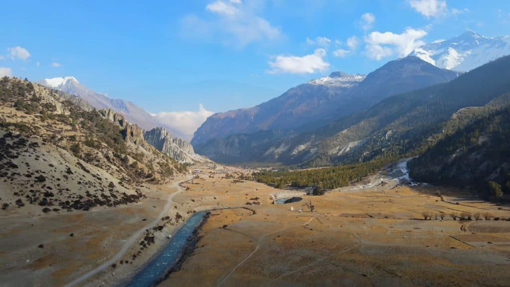
When you leave this forest the valley broadens out into more gentle terrain and the east peak of Annapurna II dominates the horizon as the track leads gradually down, past a mani stone, to a level field with a pond. The trail leads to another timber bridge over the river and through a terraced field with scattered clumps of trees. There are good views of the north face of Annapurna II. Finally, the trail skirts the lower level of the village of Upper Pisang and crosses the Marsyangdi to Lower Pisang, set at 3,200 m (10,500 ft). You can stay in one of the village’s many hotels or camp in the meadow next to the spring.
6th Days of Annapurna Circuit Trekking Guide
Take the timber bridge across the Tseram Tsan Changu, past many stones and some chorten, to the right bank and through a thick forest, climb up to the mountain pass marked by a chorten. From here you can see Manang airfield dead ahead.
The trail descends to a level section, past Ongre where the northeast face of Annapurna III is visible, to the airstrip at Omdu and then across flat broad plain and across the sabje Khola. Here the massive peak of 7,525-m (24,688-ft)-high Annapurna IV appears on the horizon.
The trail then traverses another bridge, over the trickle of the newborn Marsyangdi Khola, over to the left bank and the village Mungji, encircled by verdant farm fields. To the right, sheltered beneath a small mountain, stands Braga with its magnificent monastery.
Here there are many large chortens and mani stones and before long you arrive at Manang, set at 3,520 m (11,500 ft) beneath a panoramic vista most certainly made in heaven – from a terraced hill above the town spread out before you are Annapurna II, Annapurna IV, Annapurna III, 7,555-m (24,787-ft)-high Gangapurna and behind, 7,134-m (23,406-ft)-high Tilitso peak. Manang’s streets and houses are lined with many fluttering prayer flags and there are numerous hotels. You can stay the night in one of these or camp on their rooftops.
Total walking time to Manang is about four hours.
Most experienced trekkers recommend having a rest day in Manang to acclimatize to the high altitudes. Manang is a good place to stock up on anything you may have forgotten to bring medical supplies, warm socks and gloves and so on – and the hotels here are a cut above the average, providing luxuries such as hot shower. Throughout the trekking season, the Himalayan Rescue Association operates an aid post in the village, giving lectures on altitude sickness and providing doctor’s services.
7th days Annapurna Trekking Guide
Now begins the toughest part of the trek, through Manang and up to the village of Tinke. All along this route, you will see Annapurna Himal on the horizon with Peak 29 and HimalChuli in the distance behind it.
Tinke is the last permanent settlement in the Marsyangdi Khola valley but the path continues along up through the summer village of Kutsuanand, soon after a deserted village, the trail flattens out and crosses a bridge over the Gundon Khola. Carved out of the mountains ahead you can see the walls of the Thorung pass – your destination.
The trail now becomes a gentle switchback before crossing a delta with many yak meadows and then across the Kenzan Khola to Churi Latter (also spelled Letdar or Lathar), where there are three hotels. Some trekkers push on to Thorung Phedi, but in the interests of acclimatizing to the high altitudes, it is far better than you take this leg of the trip at a more leisurely pace. Besides the lower altitudes (4,250 m or 14,000 ft), accommodation and food are better here than at Thorung Phedi, and Churi Latter is less likely to be crowded with other trekkers.
8th Days Annapurna Circuit Trekking Guide
From here the trail climbs a gradual incline to the snout of a ridge. Then it dips down to cross the bridge over the Marsyandi Khola and ascending the mountain path on the right bank, then down a rocky section to the riverbed which it follows tor 10- to 15- minute walk. Finally, the path climbs a rocky track to the plateau and Thorung Phedi, at 4,500 m (14,750 ft), which has one combined hotel tea house, serving very basic Tibetan fare. You can bed down on its earth floor or camp nearby. When there’s snow on the pass, this cramped and not particularly friendly place can be host to up to 100 trekkers.
Approximate walking time: three hours.
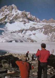
Leave early, prepared for extreme cold and severe gale-force winds as you climb the most testing section of this trek Thorung pass. Climb the zigzag trail up the steep hill in front of the hotel, through a rocky area to the top of the ridge. Here it crosses a frozen stream, then some lateral moraine and continues over a frozen lake to the glacier. The trail then traverses to the left, between small hill-like ridges above 5,000 m (16,500 ft) and soon Annapurna II, in the rear, passes out of sight. Now the angle eases as you begin the ascent to Thorung pass at 5,416 m (17,770 ft), its crest marked only by cairns and no shelter from the cruel wind.
This is one of the entrances to the eight kilometers (five-mile)-deep Lali Gandaki gorge and ahead – as you enter an old lateral moraine for the precipitous descent –Dhaulagiri II, III and Tashi Kang, rise up over the valley. The final leg is down an extremely steep cliff. Finally, you arrive at Chabarbu and it’s in a hotel. From here on out, the path flattens out through the valley and across the Khatung Kang which flows in from the left, the lunar landscape of the Hong Khola valley which you descend with magnificent views of 8,167-m (26,795-ft)-high Dhaulagiri I and 6,920-m (22,704-ft)-high Tukuche peak.
Muktinath Yatra
Once through the valley, you are approaching the checkpost at; Muktinah, set at 3,798 m (12m500 ft). there are no hotels, and no camping is allowed in Muktinath itself, but after an easy 10-minute walk down t Ranipauwa you’ll find a rash of houses, hotels, tea houses and camping sites – apple pies await the foot-weary trekker here. Approximate walking time: seven to nine hours Eleventh Day With Dhaulagiri I, Tukuche peak and Dhaulagiri II and III still in view, the trail leads down from Muktinath to Jharkot, where there are the ruins of an ancient fortress and several hotels.
Now the path passes through two stone walls to gradual descent down the mountains and leading along a wide level trail to Khingar, after which it dips gradually to a crossroads. The right-turning leads to Kagbeni, famous for the ruins of its medieval castle.
Jhomsumba Trek
The path on the left leads you down the mountain flank to the left bank of the Kali Gandaki river and Akkara Bhatti and then on to Jhomsumba in the afternoon.
Jhomsumba has an airfield that offers daily flights to Pokhara – they tend to be heavily booked. It also has a large selection of accommodation, including Om’s Home, a cut above the average, where rooms have heaters and attached bathrooms. The trek from Jhomsumba to Pokhara is the return leg of the Jhomsumba trek, sometimes referred to as the “classic teahouse trek”.
There are decent hotels all along the route and it’s unlikely that you will ever be short of the company: it’s probably the most popular trek in Nepal and it’s also used heavily by locals. The altitude on Jhomsum trek never exceeds 3,000 m (9,800 ft) – easy streets after the heights from which you’ve just come. 10 Best places for high altitude trekking in Nepal.
