
Nepal is a landlocked country located in South Asia, bordered by China to the north and India to the south, east, and west. It is a diverse country with a range of geographical regions, each with its own unique characteristics and features. Here are three geographical regions of Nepal:
Quick Links
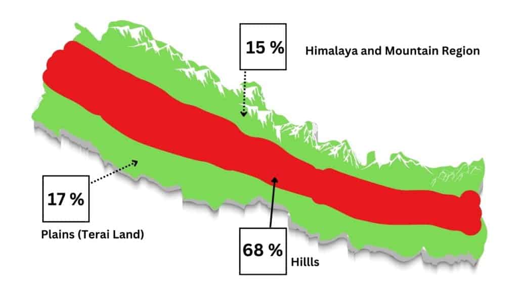
Three Geographical regions of Nepal
On top of a magnificent mountain The Himalayas, in the middle of a beautiful valley Siwalik zone The Hill Region, and the Tarai there is an awesome village made up of happy farmers.
| Geographical regions of Nepal |
|---|
| Himalaya |
| Hill Region (Siwalik Zone) |
| The Terai |
The Himalayas
The Himalayas are the highest mountain range in the world, and they form the northern border of Nepal. This region is home to some of the highest peaks in the world, including Mount Everest, the highest mountain on Earth. The Himalayas are a rugged and inhospitable region, with harsh winters and thin air at high altitudes. The region is home to a variety of flora and fauna, including rare species like the snow leopard and the red panda.
Nepal has one of the world’s highest birthrates, with its population growing so fast. The country may soon find itself hard-pressed for food. Over-cultivation of the steep valley slopes above the river gorges has already turned the landscape into a textbook case of deforestation and soil erosion.
With its steep farmlands unprotected by the deep root systems and sheltering foliage of perennial vegetation. The fierce monsoon rains wash away the fragile topsoil. It can bring thousands of tons of mountainside land sliding down the slopes. Yet the beauty of Nepal’s landscape remains virtually indestructible. The sheer scale and form, even of the eroded walls of the valleys, are still magnificent enough to take the breath away.
It is these same mountain walls that have kept Nepal remote from the world until this century.
The Hill Region (Siwalik zone)
The Hill Region is located south of the Himalayas and is characterized by rolling hills and valleys. This region is home to the majority of Nepal’s population, and it is where the capital city, Kathmandu, is located. The Hill Region has a temperate climate, with hot summers and cool winters. The region is also home to many ancient temples and monasteries, as well as a number of natural parks and reserves.
The Siwalik zone, with the Churia range, rises from the Terai to 1,200 m (4,000 ft). Its steep slopes and dry climate have left it relatively uninhabited. To the north are broad valleys, such as Rapti Dun, which in places separate the Siwalik from the Mahabharat.
The Mahabharat forms a barrier between the plains and the fertile midlands. It too is sparsely populated, but covered with terraced slopes. Most of Nepal’s water passes through this region which until very recently had lush deciduous forests that have nearly all been cut for fuelwood. Somewhat off the beaten track, it has mountain passes as low as 210 m (700 ft) and peaks over 2,700 m (9,000 ft).
More than 40 percent of the population occupies the temperate valleys of Kathmandu and Pokhara that dominate the Pagad Zone or Midlands. Here the soil is mostly alluvial and fertile; crops of nearly every kind can be grown at altitudes between 600 and 2,100 m (2,000 and 7,000 ft).
The Terai
The Terai is a low-lying region located in the southern part of Nepal, bordering India. This region is characterized by flat land and a tropical climate, with hot and humid weather year-round. The Terai is an important agricultural region, producing a variety of crops including rice, wheat, and sugarcane. The region is also home to a number of national parks and wildlife reserves, including Chitwan National Park, which is home to a variety of endangered species such as the Bengal tiger and the one-horned rhinoceros.
Until recently it was covered by dense forests filled with wildlife, from rare butterflies to Bengal tigers. Last two or three decades these forests have been widely encroached on. The woods were cut down, and the wildlife was exterminated. A massive influx of settlers means that the Terai is where the majority of the Nepalis live nowadays.
This human settlement has ravaged the Terai. Where British Hunter and explorer Jim Corbett in the 1930s stalked man-eating tigers and fished for huge fighting bream in the shade of ancient forests. There are now only eroded river valleys up to a mile wide and a patchwork of forest and cultivated areas.
For much of the year, river beds are dry. During the summer they are flooded from bank to bank with silted torrents changing course from year to year. Many houses stand on stilts. Like so many places on the planet, the Terai has become proof of the instantaneous and irreversible damage of population growth.
The mountains of Nepal have captured the imagination of countless adventurers from all over the world who crave adventure and excitement. Being at home to several world-renowned peaks like Mount Everest, Kanchenjunga, and Makalu, trekking is a beloved activity here. Let’s talk about the 3 Geographical Regions of Nepal.
